-
In 1951-52, Eldona Gold Mines Ltd. sank a shaft to a depth of 125 metres and constructed 634 metres of drifts, successfully reaching the fold nose feature of the Cadillac Larder Lake Break.
Mineralized gold zones outlined below:
Underground Development Average Back Panel Samples Assay Table
Bazooka Property
- The Bazooka property occupies seven kilometres of strike length along the prolific Abitibi Greenstone Belt on the Cadillac Larder Lake Break
- The Bazooka property is a 100% owned 1200ha land package in an excellent jurisdiction.
- Bazooka is contiguous to the western border of Yorbeau Resources’ Rouyn gold property that contains four known gold deposits 5†.
- Bazooka is contiguous to the south-western border of Monarques Gold’s Wasamac gold property that contains 2,882,000 oz Au resources5†.
- Kinross completed over 24,000 meters of drilling on the Rouyn property in 2017, with a significant amount of drilling completed within 300m of Opawica’s eastern border – the results indicate a potential continuation of the mineralized zone onto the Bazooka property
- IAMGOLD signed a definitive option agreement in December 2018 to acquire a 100% interest in the surrounding Rouyn project for C$4 million and required exploration expenditures of C$9 million over a four year period. †.
- The Bazooka property hosts significant gold mineralization at the eastern border and is open on strike for seven kilometres to the west and at depth
Historical exploration at the property shows attractive prospective geophysical signatures and high-grade drill results:
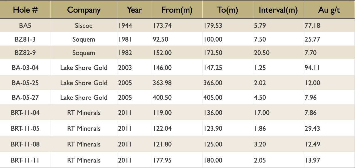
+ 77.18 g/t Au over 5.79m
+ 25.77g/tAu over 7.5m‘
+ 7.70 g/t Au over 20.5m
+ 7.86 g/t Au over 17m

High-Grade Gold Intervals
Significant gold mineralization has been established on the Bazooka Property from near surface to approximately 250 metres vertical depth from past drilling as shown in the following table.
Select Drill Hole Composite Assay Table
- Contiguous to the south-western border of Yamana Gold’s that contains a gold resource: Proven /Probable 1,767,000 oz, Measured/Indicated 2,588,000 oz, and Inferred 294,000 oz Wasamac gold property 1†
- The best gold mineralization within 15m-60m wide (estimated true width)
- Alteration/deformation zone is generally confined to 2m-10m wide (estimated true width), strongly to intensely silicified carbonatized horizon with grey or brownish quartz veins (centimetre-scale to up to 2.0 m wide, estimated true width).
- 2003-05 drilling widespread gold mineralization from few hundred ppb to up to 316.23 g/t Au over 1.0m in Hole #BA-03-02A
- Possible higher-grade Au intersections occur over narrow widths within a 50-100m-wide main alteration/deformation zone (Main Zone) over an E-W strike length of 500m, to a vertical depth of up to 350m, and open to depth.
- Historically 634m of drifts were developed at –114m level followed by 957 metres of underground
- Average of back panel samples grading 0.31 oz over 15.0 feet, average of back panel samples grading 0.55 oz over 3.5 feet by 69 feet long, average of back panel samples grading 0.06 oz over 5.3 feet by 60 feet long and channel samples grading 0.21 oz (over a drift section of 10 feet)”.
- These mineralized zones occur in a carbonated zone lying along the limbs around the nose of a drag fold
- 125 drill holes 29,595 meters of drilling
- The results of 2017 drilling and the historical holes confirm at the level of 275 m below surface, a wide gold zone extending from west to east, with widths of 40.5 m (BZ81-2) to 54.8 m (OP-17-01), 39.3 m (OP-17-02), 50.3 m (OP-17-05) and 73.1 m (BA-03-02A) over a total length of 200 m).
- The recommended work is divided into three phases:
- Phase 1 of the recommended work consists of a review of the Lake Shore Gold and RT Minerals drill core to establish a more consistent lithological code
- Phase 2 up to 5,000 m of drilling. The purpose of this phase of drilling is to obtain additional results in the central part of the high-grade gold zone associated with the four mineralized gold zones outlined by the 1951-52 underground workings.
- Phase 3 will consist of a resource estimate. The work planned for the resource estimate are an update of the database, rental of the resource estimate software, metallurgical testing and preparation of the resource estimate report.