
Overview
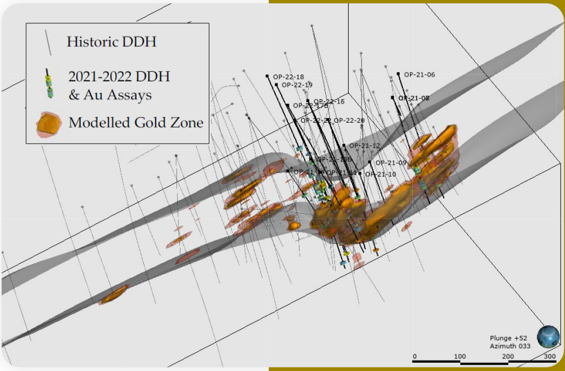
Bazooka covers seven kilometres of the Cadillac-Larder Lake Fault Zone, of which only about 15% has been systematically drill tested. The property is adjacent to Agnico Eagle’s Wasamac gold project. Gold occurs in the Main Zone, a mixed sequence of altered quartz-carbonate-sericite and talc-chlorite schists up to an estimated 60 metres wide, at the contact with a graphitic fault.
Key facts
Source: Opawica Bazooka Gold Project presentation, November 2026.
- Location
- Beauchastel Township, Québec, about 7 km southwest of Rouyn-Noranda
- Commodity
- Gold
- Ownership
- 100% Opawica Explorations Inc.
- Land package
- About 1,371 hectares (3,387 acres), covering about 7 km of the Cadillac-Larder Lake Break
- Adjacent deposits
- Agnico Eagle's Wasamac to the northwest; Lac Gold's Rouyn Gold Project to the east
- Project stage
- Advanced exploration, with 51,219 m drilled in 210 historical and recent holes
- Deposit type
- Orogenic gold (quartz-carbonate veins and bulk tonnage)
Geology
Source: Opawica Bazooka Gold Project presentation, November 2026.
- Regional control: the property covers 7 km of the Cadillac-Larder Lake Break, which separates Blake River volcanics to the north from Timiskaming sediments to the south.
- The Main Zone: mineralization is hosted in a 20 to 60 m wide deformation corridor of intense quartz-carbonate-sericite and talc-chlorite alteration.
- Structural trap: a Z-shaped drag fold near the historic shaft creates low-pressure dilation sites that concentrated high-grade, gold-bearing fluids.
- Mineralization style: quartz-carbonate veins and stockworks with pyrite and arsenopyrite, and frequent coarse visible gold.
- Key marker: a distinct graphitic fault defines the sedimentary-ultramafic contact and is a reliable horizon for drill targeting.
Infrastructure and access
Source: Opawica Bazooka Gold Project presentation, November 2026.
- Paved Provincial Highway 391 runs north-northeast through the centre of the property and connects to the TransCanada Highway.
- A network of internal bush roads allows year-round drilling.
- About 7 km southwest of Rouyn-Noranda, with access to skilled labour, suppliers and engineering.
- Serviced by the Ontario Northland Railway and within 25 km of Rouyn-Noranda Regional Airport.
- Hydroelectric power lines on site; a natural gas trunk line also crosses the property.
- Water from local sources, including Pelletier Creek, which crosses the property.
- A three-compartment exploration shaft sunk in 1951 to 125 m, with 634 m of historical drifts.
2025 drill program
Source: News release, July 10, 2025
14 holes, 3,359 metres, 978 samples. The Company reported gold in every completed hole. Holes OP-25-24, OP-25-30 and OP-25-32 were abandoned or lost at 36 m, 96 m and 81 m.
OP-25-33
67.9 m at 0.84 g/t Au
including 7.5 m at 3.65 g/t Au
OP-25-25
10.0 m at 2.15 g/t Au
near surface
OP-25-29
29.0 m at 0.39 g/t Au
including 12.0 m at 0.87 g/t Au
OP-25-28
15.5 m at 0.31 g/t Au
including 7.5 m at 0.60 g/t Au
| Hole | Result | Detail |
|---|---|---|
| OP-25-33 | 67.9 m at 0.84 g/t Au | including 7.5 m at 3.65 g/t Au |
| OP-25-25 | 10.0 m at 2.15 g/t Au | near surface |
| OP-25-29 | 29.0 m at 0.39 g/t Au | including 12.0 m at 0.87 g/t Au |
| OP-25-28 | 15.5 m at 0.31 g/t Au | including 7.5 m at 0.60 g/t Au |
Uncut weighted averages. Intervals are drilled core lengths; true widths are not yet determined.
The program identified 19 gold-mineralized zones: 15 grading above 0.55 g/t Au, up to 6.12 g/t Au, and 16 with core lengths of more than 10 m. Broad mineralized zones were also logged in OP-25-35 (60 m) and OP-25-27 (42.5 m) (company news releases, April 8 and April 17, 2025).
2025 drilling in 3D
Loading 3D view
Hole log
Hover or tap an interval for detail.
| From | To | Length | Au g/t | Note |
|---|---|---|---|---|
| 292.5 | 360.4 | 67.90 | 0.84 | Deep extension down plunge of historical drift |
| 292.5 | 300.0 | 7.50 | 3.65 | Including. 70% white quartz stockwork with trace of very fine pyrite |
| 325.5 | 331.5 | 6.00 | 2.10 | Including. Sericitized greywacke with arsenopyrite |
| 337.5 | 342.0 | 4.50 | 1.63 | Including. Sericitized greywacke with arsenopyrite |
| 347.8 | 349.5 | 1.75 | 1.56 | Including. Greyish quartz vein with visible gold |
- Below 0.30 g/t Au
- 0.30 to 0.99 g/t Au
- 1.00 to 2.99 g/t Au
- 3.00 g/t Au and above
Schematic model built from the collar and assay tables in the Company's July 10, 2025 news release. Hole traces are straight lines from collar azimuth and dip; downhole surveys have not been published. Intervals are core lengths; true widths are not yet determined. Assays are uncut weighted averages. Read the July 10, 2025 news release.
2021 to 2022 work
- More than 5,000 metres of drilling
- 3D structural and geological modelling
- Target generation with ALS GoldSpot Discoveries
- An M-PASS airborne survey
- A 3D IP survey by Abitibi Geophysics
- A downhole televiewer survey
OP-21-13
3.0 m at 8.21 g/t Au
including 1.6 m at 13.70 g/t Au
OP-22-20
3.0 m at 6.48 g/t Au
including 1.0 m at 18.70 g/t Au
OP-22-22
7.2 m at 2.34 g/t Au
| Hole | Result | Detail |
|---|---|---|
| OP-21-13 | 3.0 m at 8.21 g/t Au | including 1.6 m at 13.70 g/t Au |
| OP-22-20 | 3.0 m at 6.48 g/t Au | including 1.0 m at 18.70 g/t Au |
| OP-22-22 | 7.2 m at 2.34 g/t Au |
Core lengths. Source: Opawica corporate presentation.
Targets
Source: Opawica corporate presentation, October 2025.
3D lithostructural modelling identified 15 structures controlling mineralization, shears in a Riedel-like system associated with quartz-carbonate stockwork. Targets generated in 2021 were validated by the 2021 to 2022 drilling, and several targets remain untested.
Exploration history
Source: Opawica Bazooka Gold Project presentation, November 2026.
Selected campaigns
- total drilling, historical and modern
- 51,219 m
- diamond drill holes
- 210
- vertical shaft, 1951
- 125 m
- of underground drifts
- 634 m
2025
Opawica, Phase 2
3,359 m in 14 holes; 67.9 m at 0.84 g/t Au (OP-25-33).
2021–22
Opawica, Phase 1 with ALS GoldSpot targeting
5,022 m in 21 holes; 18.7 g/t Au over 1.0 m and visible gold in multiple holes.
2017
Opawica
2,172 m in 5 holes; 54.8 m at 0.65 g/t Au.
2011–12
RT Minerals
5,557 m in 20 holes; 7.86 g/t Au over 17 m.
2003–05
Lake Shore Gold
11,029 m in 32 holes; 316.23 g/t Au over 1.0 m.
1980–86
SOQUEM
4,023 m; 40.5 m at 2.34 g/t Au and 7.5 m at 25.77 g/t Au.
1951–52
Eldona Gold Mines
Sank a 125 m vertical shaft and developed 634 m of drifts.
1944–46
Siscoe Gold Mines
Discovery campaign of 5,858 m; 77.18 g/t Au over 5.79 m.
Historical results predate Opawica’s work, are reported as core lengths as disclosed by the Company, and should not be relied upon as current results.
Conceptual exploration target
Source: News release, October 16, 2025
The Company is exploring for a conceptual exploration target of 10 to 40 million tonnes grading between 0.90 and 1.45 g/t gold, based on 210 drill holes totalling 51,219 metres. The Company has described this as 1.5 to 2.0 million ounces of gold (company update, January 20, 2026).
What is next
Source: company news releases, July 10, 2025 and January 20, 2026; Opawica Bazooka Gold Project presentation, November 2026.
- Historical and recent drilling has focused on a stretch of about 1 km near the historic shaft.
- About 6 km of strike along the Break remains largely untested, or tested only by shallow historical holes.
- The Company plans to drill westward toward Agnico Eagle's Wasamac trend.
In January 2026 the Company said it is exploring a joint venture or sale of Bazooka. About 7,000 metres of high-priority targets remain to be drilled, and the property is open to the north, south, west and at depth.
Technical information has been reviewed and approved by Yvan Bussieres, P.Eng., a Qualified Person as defined by National Instrument 43-101.